

The Spel’kúmtn Community Forest Tenure
The SCF holds an area-based tenure on land surrounding the Village of Pemberton and Mount Currie communities. More specifically, it lies in the areas of Green River, Signal Hill, Miller and South Miller Creek, Mackenzie Basin, Owl Ridge, Mosquito Lake.
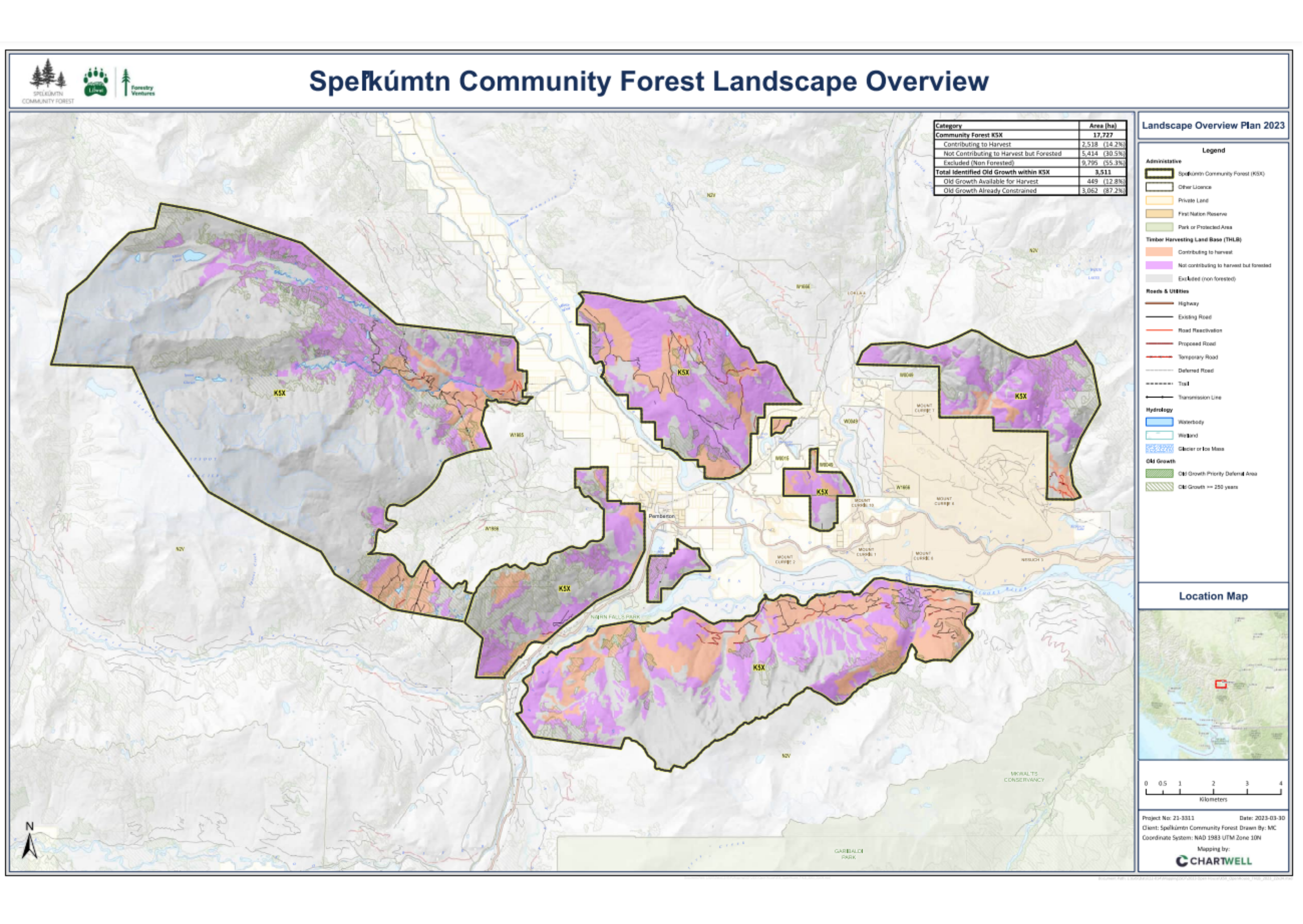
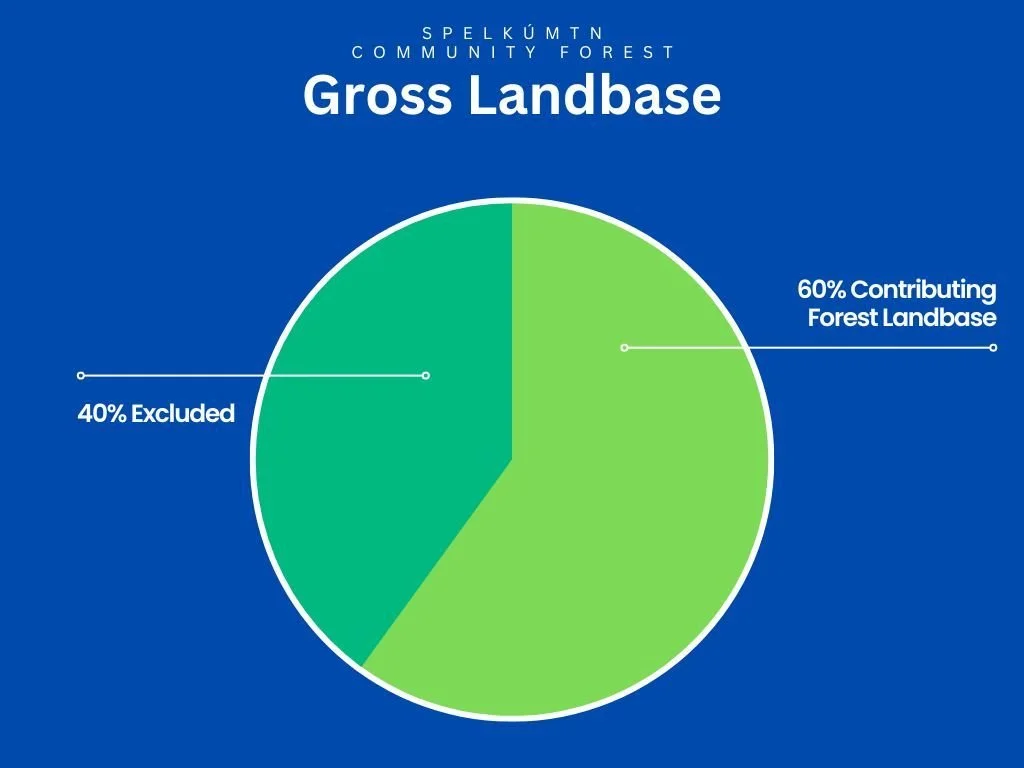
The total tenure is 17,727 hectares of land, the majority of which is designated as non-harvesting to support values such as wildlife habitat areas, old growth management areas, ungulate winter ranges, other Land & Resource Management Plans or otherwise 'excluded'.
The Timber Harvest LandBase is only one of the values designated within the Contributing Forest Landbase of the Speĺkúmtn Community Forest tenure.
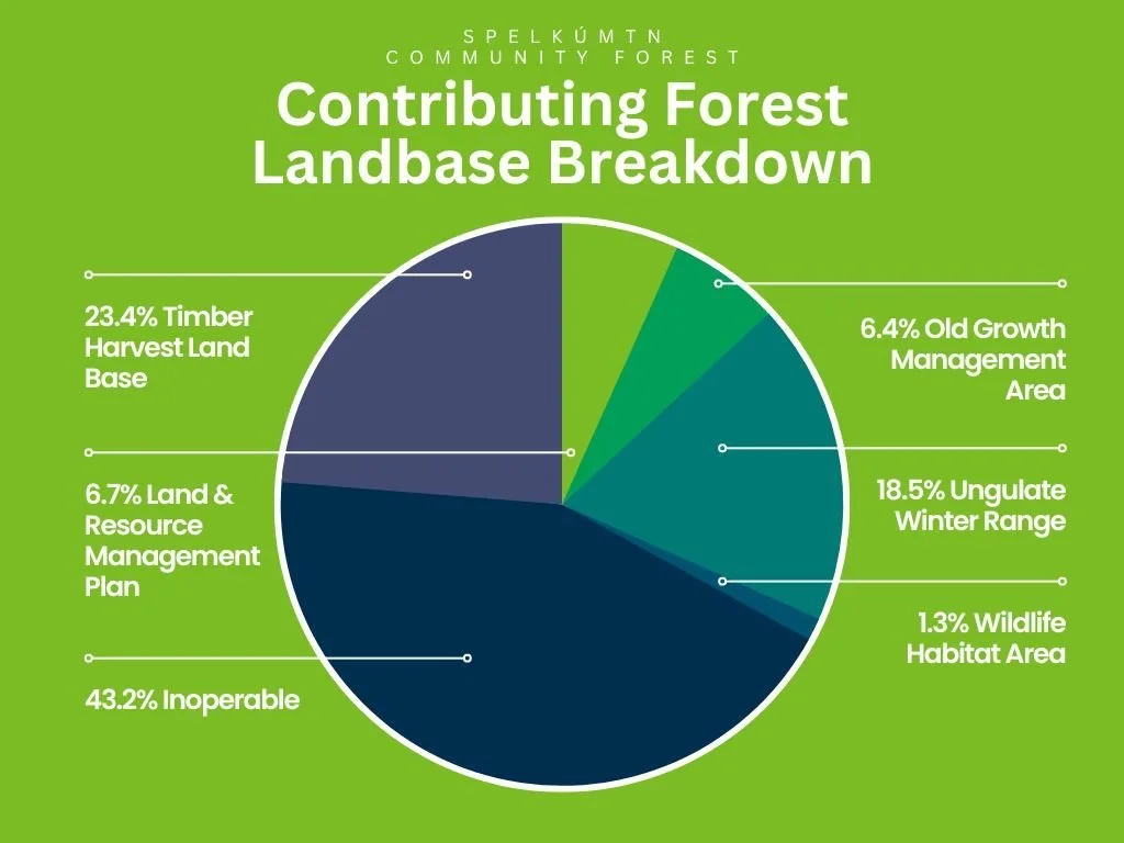
Timber harvesting occurs in approximately 2,520 hectares of the tenure area, described as the Timber Harvesting Land Base (THLB).
Key Documents
FOREST STEWARDSHIP PLAN
The FSP specifies the legal requirements as set by government. Any management activities or prescriptions developed from management plan direction must be consistent with all relevant forestry legislation and applicable Higher Level Plans as defined in the FSP.
FOREST MANAGEMENT PLAN
The purpose of the management plan is to link the partner communities and their values to the management of the Community Forest. It outlines the guiding principles, social, economic and resource management goals and objectives for the Community Forest.
COMMUNITY FOREST INDICATORS
Since 2014 the BCCFA has conducted an annual survey of its members to measure the benefits that community forests generate. Eighteen indicators provide tangible, quantitative information on the economic, social, cultural and environmental benefits of community forests.
MAPS FOR 2020 MANAGEMENT PLAN
These maps offer a visual representation of the values included in the management plan: overview; BEC and forest cover; visual inventory; wildlife, water and old growth; cultural features; recreation and other tenures; slope theme map.

FAQs
-
Fuel thinning activities can involve a range of treatments. Developed by a Registered Professional Forester, these area-specific treatments (sometimes known as prescriptions) can include removal of small understory trees, removal of woody debris (sticks, limbs, logs, etc.) from the forest floor, removal of the branches from the lower portion of trees, removal of a percentage of trees in a stand so there is less continuous tree crown cover, and a variety of other treatments. The objective of the treatments is to reduce the flammability of an area by reducing the amount of burnable material, so that a fire is less likely to start, and if a start happens, it will spread more slowly and has less potential to blow up into an uncontrollable destructive fire.
As with most forest management planning, wildfire reduction planning would also consider the range of values on a particular site (recreation values, wildlife values, visual impacts, etc.) and tailor the treatment to be consistent with the range of objectives for the variety of values. This planning would include looking at options to access the site and determine what roads would be necessary for use to complete the treatments. Again, the range of values / current uses of roads would be considered as part of the existing site values and the plan would address protection / management of existing values.
There are a number of examples of fuel thinning treatments that have occurred in the Sea to Sky, particularly in Whistler over the past 6-8 years adjacent to the resort. Some example area of treatments that have occurred include behind Kadenwood in Creekside, around the athlete’s village in Function, above the Alpine meadows sub-division and around the Olympic Park in Callahan. These treatments have all been planned and completed with input from local users / neighboring communities to the treatment areas.
Currently the fuel thinning treatment areas identified are candidate areas and no detailed fuel thinning plans have been developed. The fuel thinning treatments are quite expensive to complete and although a small amount of merchantable timber may be generated during treatments the amount would not cover the costs of the treatments. It is expected that any fuel thinning treatments that are completed would be done in partnership with Provincial/Regional government partners under community protection funding. It is the intention of the community forest to explore options that are available to access funding for community wildfire protection from the various levels of government. If funding is received fire proofing treatment prescriptions would be developed in consultation with the community and various stakeholders.
-
Full length harvested logs are very valuable and need to be put towards the business operations, so that the Speĺkúmtn Community Forest (SCF) operates as a viable business. Offcuts and woods waste will be piled at roadsides and will be available for the public to salvage provided they obtain a “Firewood Permit”, which is available for free from Ministry of Forests, Lands, Natural Resource Operations and Rural Development (MFLNRORD). When acquired the permits specify the conditions under which firewood may be collected. Cutting of full length logs for firewood is illegal. The SCF is open to exploring additional ways to facilitate salvage opportunities for Liĺwat and Pemberton community members, including for firewood use.
-
There are two parts to this answer. Firstly, not the entire SCF area will be designated as “Timber Harvesting Landbase (THLB)” (i.e. land that is available and suitable for timber harvesting and contributes to the Annual Allowable Cut). Of the forested land within the SCF only about 2500 hectares (approximately 24%) will be eligible for timber harvesting. The rest includes areas set aside for biodiversity, wildlife, riparian, cultural values and inoperable areas. The SCF also includes large areas of non-forested land such as sub-alpine and alpine areas.
In those portions of the landscape where timber harvesting is allowed, a variety of harvesting systems will be used. The choice of harvesting system depends on the unique context of each particular site, and includes consideration of soil conditions, wildlife habitat, riparian, cultural, recreation, visual and other values. Clearcutting may be applied on small areas if appropriate on a particular site. The main harvesting system will likely be partial retention, in which a portion of trees are retained in various spatial patterns.
-
Maintaining the visual quality of viewscapes is specified as an objective in the SCF Management Plan and visual aesthetic values will be a main factor in the choice of harvest system and design of cut patterns.
Visual Quality Objectives (VQOs) legally established at the District level apply to most of the SCF and call for partial retention which excludes the creation of large visibly cut areas.
Visual impacts and viewscapes were an important consideration in the timber supply analysis for the Community Forest, recognizing that a large portion of the SCF is highly visible from Highway 99, Pemberton Meadows Road, and Portage Road. They were considered in conjunction with other identified values such as biodiversity, soils, cultural values and recreation.
-
Most of the road access systems for the SCF are already in place. Smaller in-block spur roads may be developed. Many of these spurs will be deactivated and reforested after timber harvest, at which point they will be inaccessible to vehicles.
If main roads were to be developed or managed by the SCF, they would not be gated unless deemed necessary for the protection of wildlife (e.g. grizzly bears) or other forest values. Permission from the Ministry of Forests, Lands, Natural Resource Operations and Rural Development is required prior to gating any roads on public land.
-
One of the management goals for the SCF is to protect and enhance recreational values for community use and tourism. The SCF will foster relationships with recreation related and trail groups (e.g. Pemberton Valley Trails Association, Pemberton Off Road Cycling Association, Pemberton Wildlife Association), and work in cooperation with community groups to manage the recreation resources on the SCF landbase. The SCF will participate with these groups in exploring new recreation opportunities es not have the authority to approve new trails. Authorization for the construction of new trails must be obtained from the Ministry of Forests, Lands, Natural Resource Operations and Rural Development (MFLNRORD). The SCF is open to collaborating with community groups in the trail design and application process, with due consideration to cultural and ecological values.
-
One of the management goals for the Community Forest is to provide economic and social benefits to the Liĺwat and Pemberton communities. Specific decisions regarding the distribution of profits will be made by the SCF Corporation Board of Directors with due consideration of community input.
Determining procedures for distribution of profits will be one of the first tasks of the permanent Board of Directors once it has been appointed. A Distribution Policy will be developed that outlines how profits will be distributed.
-
Fuel thinning entails the removal of fine fuel accumulations from the forest floor and lower branches of trees to reduce the risk and intensity of wildfires. Specific methods depend on the site but can include removal of accumulations of fine woody debris up to 10cm diameter from the forest floor, pruning lower branches of larger trees, and cutting and removal of small understory trees in areas of high density.
-
The SCF intends to work with community groups to manage recreation values, including trails, across the Community Forest area. The presence of and proximity of trails will be considered in the location and design of proposed harvest areas. Since the landbase available for timber harvesting within the Community Forest is relatively limited, there may in future be an overlap of proposed harvest areas with established trails. If harvesting around an established trail is proposed the SCF will work closely with community groups to make sure the recreation trail feature remains after harvest. This may entail reestablishing, rerouting and/or enhancement. That said, some existing trails, for example much of Mackenzie Basin, lie within areas where timber harvesting is already limited or prohibited due to other values such as deer winter range.
-
A key guiding principle for the Community Forest is that forestry operations will be managed to show a profit, and demonstrate the value and viability of forestry to the Village of Pemberton and the Liĺwat Nation. Decisions regarding the distribution of profits will be made by the SCF Corporation Board of Directors with due consideration of community input, and in keeping with the SCF goal to provide economic and social benefits to Liĺwat and Pemberton communities. Determining procedures and annual priorities for distribution of profits will be one of the first tasks of the Permanent Board of Directors once appointed. A Distribution Policy will be developed that outlines how profits will be distributed to each community.