
OneMile Lake Fuel Thinning - Fall/Winter 2023-2024
Project Update - February 6th, 2024
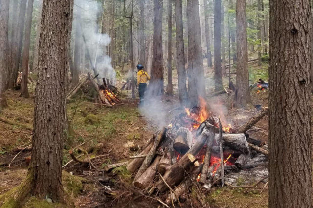
Crews are making good progress on the project:
4.34ha have been thinned and piled, leaving 1.76ha - the most southerly portion - remaining to be thinned
pruning of branches will follow and there are some pockets throughout the treatment area, previously covered by snow, that will require additional cleanup
burn piles are scattered throughout the area; timing of the burn will depend on permitting and venting conditions
Please DO NOT enter the work area while crews are operating. Thanks for your patience!
Kukwstum’ckál’ap (thank you) to all the crew members working so hard out there. Stay safe!

Spel’kúmtn Community Forest and Líl’wat Forestry Ventures, through funding from the Forest Enhancement Society of BC, will be carrying out fuel thinning work in the OneMile Lake area. The project encompasses high hazard forest land and is part of ongoing work to reduce risk to nearby residences, infrastructure and downtown Pemberton.
We recognize this is a high use trail area and Líl'wat Spirited Ground. Extensive engagement has been done with Líl'wat Nation and trails organizations. Key planning parameters were to reduce impacts to trails and sensitive ecosystems while still achieving risk reduction objectives. Líl'wat Forestry Crews will be conducting the work - manual pruning, piling and burning - with work anticipated to start on January 8th, 2024.
Some trails will be closed for public safety - green area on map above.
Please obey all signs and instructions.
Sea to Sky Trail - from just south of the bridge at OneMile Lake to just north of the distinct switchbacks (approx 2km from Nairn entrance)
Piece of Cake - entire trail
Overhill - majority of the trail
Nairn-OneMile - very northern end as it joins Overhill
Project objectives:
• reduce the rate of spread and intensity of possible fires in this area •
• maintain ecological and cultural values •
• enhance public safety and fire crews’ ability to action possible fires •


Methods:
Manual understory thinning of trees up to 12.5cms
Reducing fine surface fuels to reduce surface fire intensity and rate of spread
Pruning of retained trees to reduce ladder fuel continuity
Retention of all overstory trees to maintain crown closure and encourage a cooler and moist understory microclimate
Retention of all live deciduous tree and shrub species with high moisture content to reduce fire behaviour and provide wildlife habitat
Retention of all wildlife trees not classified as ‘danger trees’ (trees that pose imminent danger to workers or the public
Cultural areas and trails
An archeological assessment was be completed for the treatment area prior to project implementation. Known archaeological sites have been removed from the treatment area.
High value trails have been identified by local trails associations and will retain a reduced treatment buffer along both sides. Understory trees integral to delineation and trail structure will be retained along all trails.
Debris removal
Pile burning or chipping will be used to remove debris.
Burn piles will be small (3x2m) to minimize scorching and heat damage, and will be distanced from trails, burrows, snags.
Chips may be lightly distributed discontinuously throughout the treatment area; they will not be piled and left.
Some ‘critter piles’ may be deliberately created. These provide some of the function of large downed logs found in older forests.
Smoke
The area is designated a high smoke sensitivity zone. Strategies required to reduce the impact of burning:
minimize amount of fuel to be burned
season piles prior to burning
timing and length of burn are controlled
venting index must be appropriate for ignition
Wildland Urban Interface (WUI - ‘woo-ee’)

A community’s wildfire risk is the combination of hazard (likelihood and intensity of fire) and vulnerability (exposure and susceptibility of homes or other values).
The Wildland Urban Interface is where combustible forest fuels are found near homes, structures or other values. The Village of Pemberton, SLRD and Líl’wat Nation have community wildfire plans to prioritize and guide risk reduction work. Pemberton is located in Risk Class “1”, the highest wildfire risk rating. In coming years, there will be increased fuel thinning and fire mitigation work within the WUI to provide added protection to our local communities.

Historic fire regimes
Forests in this area would normally have experienced frequent, low-intensity fires that would remove understory vegetation and maintain larger, fire-resistant trees. This regime was likely upheld through pre-settlement cultural burning practices by the Lil’wat’úl.
Using traditional ecological knowledge, the Líl’wat Nation has been reintroducing stewardship through fire to its land management practices, as in this cultural burn project at Owl Creek.